Official vector charts,
rendered properly.

NavView is a chart plotter for passage planning and situational awareness. A real IHO S-57 / S-52 engine — not a pre-styled tile viewer — under an instrument panel built to be read at the helm.
Free · every feature unlocked No accounts · no telemetry
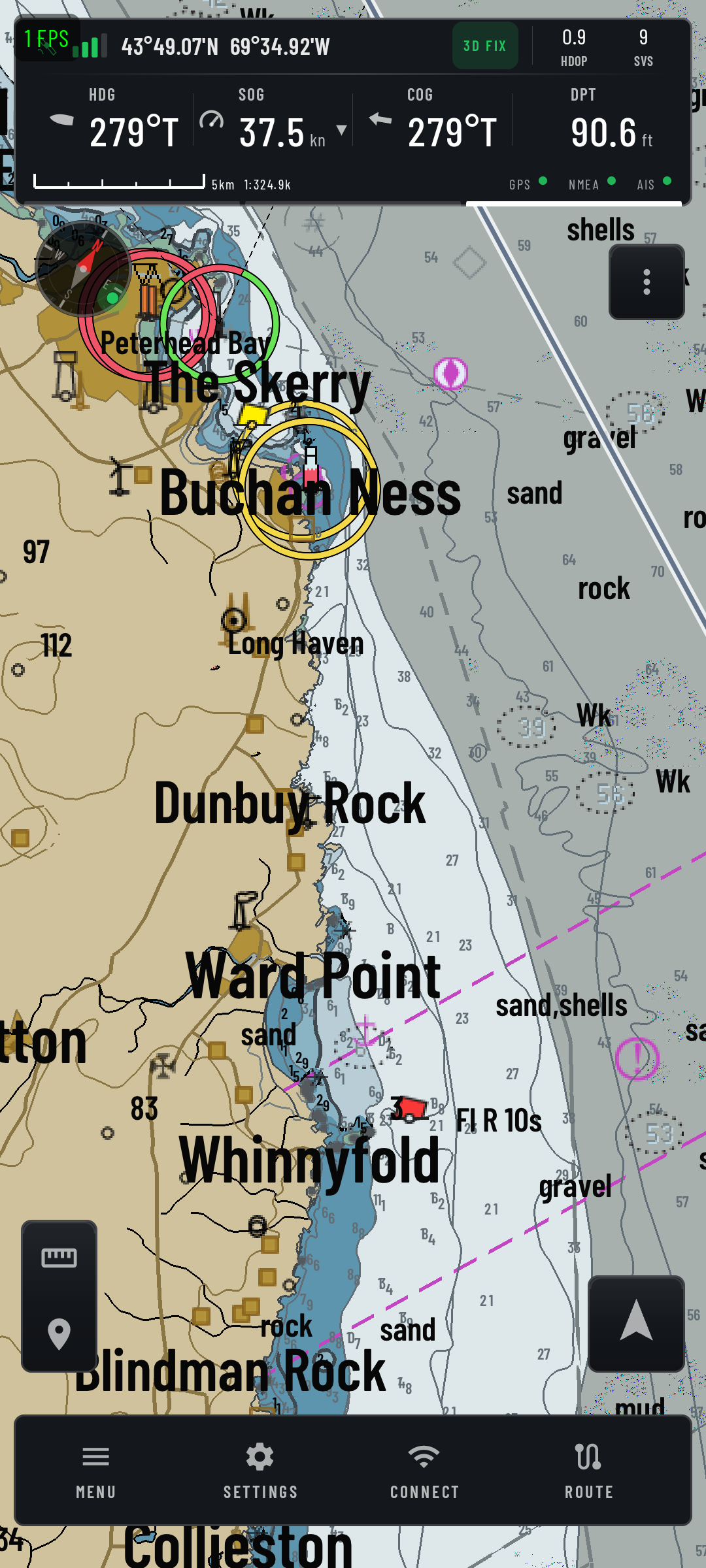
NavView showing quilted S-57 vector charts off Buchan Ness, with the status bar reading heading 279°T, speed over ground 37.5 knots, course over ground 279°T and depth 90.6 feet.
Chart canvas · status bar · chart bar
Chart formats 7 S-57 · OSENC · .nav · BSB/KAP · GeoTIFF · MBTiles · PMTiles
NMEA 0183 sentences 79 Decoded across nine categories, each one explained in-app
GRIB parameters 12 Six additive render layers, eleven colour schemes
Router outputs 6 TCP server · UDP · TCP client · BT SPP · USB · file log

A chart engine,
not a tile viewer.

Most mobile plotters ship charts as pre-styled raster or vector tiles baked on someone else's server. NavView carries an OpenCPN-lineage S-52 presentation library and renders official S-57 cells on the device, at read time.

  • Full S-52 symbology Paper or simplified point symbols, plain or symbolised area boundaries, four-shade depth colouring, and live light-sector geometry with nominal range and colour.
  • Quilting across cells Seamless multi-cell display with reference-chart picking, territory clipping and LRU eviction — no seams, no swapping charts by hand.
  • Display Category and Mariner Selectors Safety, Routine, Full or Custom. Accuracy and ZOC hatching, full light lines, SCAMIN handling, de-cluttered and important-text-only modes.
  • A baked world basemap OpenStreetMap land to pier level, Natural Earth bathymetry bands and a GEBCO undersea-name gazetteer, all on the device. The plotter is never blank, anywhere, with no signal.
Chart quilt Quilted ENC cells at harbour zoom, showing depth areas, buoyage and light sectors Slot 01 · phone portrait
Slot 01 — chart quilt

What is on board

Nine surfaces you will use on passage. Each opens as a drawer over the plotter, so the chart never leaves the screen.

ENC charts

Official S-57 cells with S-52 symbology, plus OSENC, encrypted .nav packs, BSB/KAP, GeoTIFF, MBTiles and PMTiles vector tiles. Import a folder, a ZIP or a single file.

7 formatsQuiltedSENC cache

Chart store & library

Library, Store and My Charts. Browse packs by coverage polygon, edition and cell count, then keep them on the device — no online open checks once a pack is down.

67 packsUS freeOne-time

Instruments & dashboard

Navigation, Sailing and Motor pages. Pin compass, wind, depth and speed gauges anywhere on the plotter, then long-press to move, resize or swap them.

19 quantitiesFloating gauges

Routes & passages

Build multi-leg routes on the chart, rhumb line or great circle. Passage face with ETA, TTG and leg breakdown; XTE corridor rails; per-waypoint arrival radius and planned speed.

GPXSend to GPSCDI

Marks & tracks

329 bundled markicons in twelve categories. Track recording ported faithfully from OpenCPN's commit algorithm, with daily rotation, jump filtering and Douglas–Peucker reduction.

329 iconsForeground service

Anchor watch & MOB

Two independent watch points, each with its own ring. Drift mode alarms when you leave the swing fence; keep-out mode alarms when you enter. Hold MOB to raise a man-overboard mark.

Watch 1 + 2Survives screen-off

AIS traffic

Class A and B over 0183 VDM/VDO or eight NMEA 2000 PGNs. Threat and Clear sections, CPA and TCPA cues, true vessel dimensions at close zoom, lost-target handling.

Danger · Near · ClearCPA/TCPA

Weather

GRIB overlay for the live forecast — wind, pressure, waves, current and more. Separately, an ERA5 climate face for what the month usually does before you commit to a passage.

GRIB1 + GRIB2ECMWF · NOAA

Connections & router

Seven input types, six output sinks, per-category forwarding and a source arbiter. Your phone becomes the multiplexer — it can feed OpenCPN as easily as it reads your instruments.

0183 + N2KBLE · USB · TCP

Two watches,
because one is not enough.

A stern anchor, a shore line, a rock you want to stay off — each gets its own ring. Watch 1 can alarm when you leave your swing fence while Watch 2 alarms if you drift into a keep-out ring.

  • Runs as a foreground service Screen off, app backgrounded, or after a system restart — the watch stays armed and restores its state.
  • Losing your fix is an alarm condition No valid fix for the stale window while armed alarms every active watch, not just the first one.
  • Drift rate, not just distance Bearing, maximum excursion, drift rate and margin to the fence, over a polar swing plot with a rolling trail.
Watch 1 Watching
Drift · alarm outside · 048°T from anchor
21.4m of 35 m fence
Max 28.9m
Rate 0.2kn
Margin 13.6m
Anchor drawer The armed anchor watch drawer with its polar swing plot Slot 02 · phone portrait
Slot 02 — anchor watch drawer

Your phone as the multiplexer

NavView is not only a consumer of boat data. It takes seven kinds of input, arbitrates between competing GPS sources, and rebroadcasts filtered NMEA to anything else on board — including OpenCPN on a laptop at the chart table.

Inputs7
Device GPS
The internal GNSS receiver
Treated as an NMEA source like any other, so it can be arbitrated against or overridden by a better fix.
Bluetooth · BLE
Classic SPP and Low Energy pucks
Paired SPP devices, or scan for a BLE GPS or NMEA bridge.
USB serial
USB OTG adapters at a selectable baud
Plugging in a recognised adapter can bring NavView straight up.
TCP · UDP
Network NMEA over the boat's Wi-Fi
Connect to a remote server, or listen for datagrams on a port.
NMEA 2000
Actisense NGT-1 and Yacht Devices gateways
Fast-packet reassembly and a canboat-derived PGN dictionary, with category filtering and an N2K-versus-0183 preference.
Simulator
Every sentence type, no hardware
For setting the app up on the sofa before you set it up on the boat.
Outputs6
Router sinks
TCP server · UDP broadcast · TCP client · BT SPP server · USB · file logger
Forward by category — GPS, AIS, instruments — so each listener gets only what it needs. File logs are timestamped for later replay.
Fix quality Sky plot, per-satellite signal bars and the interference watch Slot 03 · phone portrait
Slot 03 — fix quality drawer

Know how good
your position is

Most plotters show you a position. NavView shows you how much to trust it — GNSS quality is a first-class instrument, not a hidden diagnostic.

  • Sky plot and per-satellite signal Elevation and azimuth referenced to true north, SNR bars per satellite, constellation chips and multi-band detection.
  • Quality trend HDOP, VDOP, PDOP, fix age, differential age and a 300-second rolling CEP so you can see degradation coming.
  • Interference watch Flags RF interference and possible spoofing, and points at obstruction by azimuth sector — antenna obstructed NW, check mast and deck gear.

An instrument panel
that holds still

The interface follows one rule above the rest: it behaves like a marine multi-function display, not like an app. Nothing slides, fades or reflows while you are trying to read a number off it.

Layout does not breathe

Columns are width-locked and slots are reserved even when empty, so a timestamp never shifts mid-scroll. Panels snap open. Only needles and glyphs animate.

Glove-first targets

44 px is the floor for anything you press. Destructive actions arm before they fire — stopping a recording is two taps, and the arm window closes itself after three seconds.

Readable in sunlight

Condensed tabular numerals, uppercase micro labels, hairline rules and recessed wells. Labels never dim, because a label you cannot read is a value you cannot use.

Five chart palettes

Day, Dusk, Night, Dark and Paper repaint the chart for the light you are in. The app's own chrome stays dark throughout, so nothing flares at you on a night watch.

No stale numbers

When a datum is missing you get one blank mark — an em dash — never the last value it happened to see. The scale bar draws nothing rather than a wrong-length bar.

It tells you what it cannot do

A 32-topic manual ships in the app and is candid about limits: CPA cues are visual, there is no depth sounder alarm, draft is stored for reference. Fewer surprises at 0300.

No account.
No telemetry.

Every feature in the app is unlocked. There is no premium tier, no subscription and no sign-in. Charts are the only thing that costs money, and US waters are free.

No accounts
There is no login, no cloud and no user database. Routes, marks, tracks and vessel profiles live in the app's private storage on your device.
No analytics
No analytics service, crash-reporting SDK or advertising library is compiled into the app.
Network use
The internet is touched for exactly four things: the chart catalogue and pack downloads, GRIB fetches, the climate pack, and any NMEA link you configure yourself.

Ready to plot?

NavView is free on Google Play. Bring your own charts, or start with the free US coverage in the store.

Coming soon to Google Play Get the launch note

Requires Android 8.0 or later on a 64-bit ARM device. Phone and tablet.